Το καλάθι μου
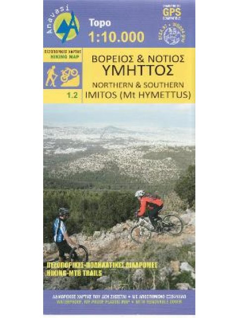
ΒΟΡΕΙΟΣ ΚΑΙ ΝΟΤΙΟΣ ΥΜΗΤΤΟΣ • ΠΕΖΟΠΟΡΙΚΟΣ ΧΑΡΤΗΣ 1:10 000
- Εκδότης:ΑΝΑΒΑΣΗ
- Ημ/νία Έκδοσης:01/01/2022
Περιγραφη
Χαρακτηριστικα
"Two very detailed maps (printed on both sides) for Mt Imittos. The first (northern) covers the part of the mountain that extends between Agia Paraskevi and Ilioupoli and from Glyka Nera to Koropi while the second covers all the remaining southern part, between Argyroupoli, Glyfada, Koropi and Vari."
ΚΩΔΙΚΟΣ E-plateia: 323281
ΜΗ ΔΙΑΘΕΣΙΜΟ
ΔΕΙΤΕ ΕΠΙΣΗΣ

Η ΘΕΣΣΑΛΟΝΙΚΗ ΤΟΥ 20ΟΎ ΑΙΩΝΑ : ΙΣΤΟΡΙΑ – ΚΟΙΝΩΝΙΑ – ΜΝΗΜΕΙΑ – ΜΟΥΣΕΙΑ – ΤΟΠΟΣΗΜΑ ΤΗΣ ΣΥΓΧΡΟΝΗΣ ΠΟΛΗΣ
20,00€18,00€
1-4 εργάσιμες